ssdd
Hazard to Others

Posts: 211
Registered: 13-4-2007
Location: Central Canada
Member Is Offline
Mood: Hypergolic
|
|
NOAA Satellite Reception
I thought I would share one of my current projects that I have been posting about on another forum, but I think is interesting enough to post about
here as well.
This involves picking up the signals from the NOAA polar orbiting satellites and turning their APT transmission at 137-138MHz into a usable image of
the earth, primarily to be used for weather.
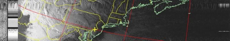
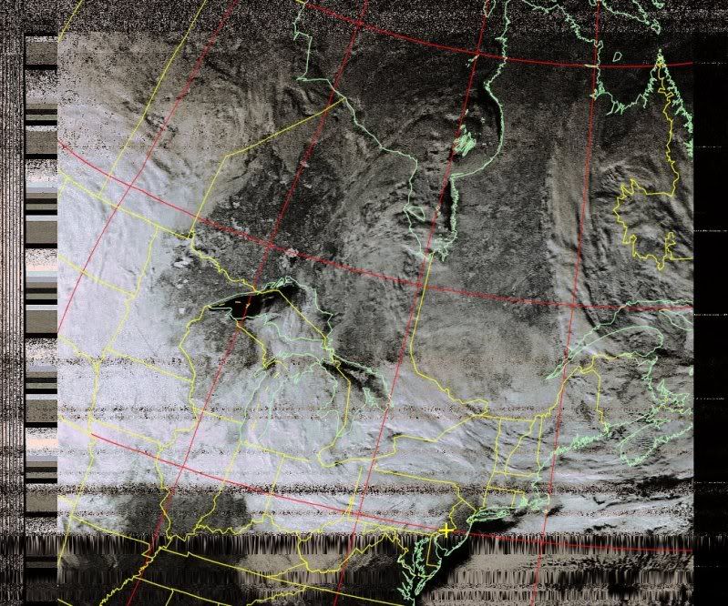
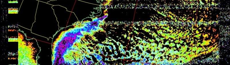
The current active NOAA satellites are NOAA-15, 17, 18, and 19. They transmit live images as they orbit the Earth (they are polar orbiting, moving
from pole-to-pole in ~100 minutes, covering the whole earth in 12 hours) at 137-138 MHz, specifically 137.1, 137.5, 137.62, and 137.9125MHz.
To receive this I use a police scanner that covers the 137-138 range. The trick to using scanners and not something better is making sure that the
scanner has a wide audio bandwidth, otherwise data will be cut off due to low bandwidth.
To my scanner I hook a 30 meter dipole antenna which is stretched between two buildings at a height of 2 meters. Using this I am able to get a clear
signal off of all four active NOAA satellites. (Though this is not the suggested antenna for the job, but it works)
From here the scanners audio out is hooked to a computers microphone jack. A program called wxtoimg is used to demodulate the signals into images.
http://wxtoimg.com
Satellite tracking is done by heavens-above.com
Using this fairly cheap and easy setup some pretty good images can be obtained, even living in a heavily populated area just outside of a major city.
NOAA 15, 1-5-2010 (black and white visible data)
NOAA 19, 1-5-2010 (color enhanced visible data)
NOAA 19, 1-7-2010 (sea surface temperature data)
I thought I would share since I found the project to be so interesting, I go into lots more detail on my webpage: http://scienceunderground.110mb.com/projects/3.php as well as the IndieScience forum...
-ssdd
PS sorry for the large images, let me know if you would like them scaled down or removed altogether...
All that glitters may not be gold, but at least it contains free electrons.
-- John Desmond Baernal
http://deepnorth.info/ |
|
|
Polverone
Now celebrating 21 years of madness
Posts: 3186
Registered: 19-5-2002
Location: The Sunny Pacific Northwest
Member Is Offline
Mood: Waiting for spring
|
|

I don't have much productive to say, but I think what you managed is pretty cool. Thanks for sharing!
PGP Key and corresponding e-mail address
|
|
|
watson.fawkes
International Hazard
Posts: 2793
Registered: 16-8-2008
Member Is Offline
Mood: No Mood
|
|
I answered one of my questions by reading your web page. Namely, you're only listening to one satellite at a time. What band is the high-resolution
data on?
Have you considered using software-defined radio for this project? You're in a band where you can get the radio parts for this off the shelf.
|
|
|
franklyn
International Hazard
Posts: 3026
Registered: 30-5-2006
Location: Da Big Apple
Member Is Offline
Mood: No Mood
|
|
In the early days of spy satellite deployment ham radio amateurs
could identify telemetry signals originating from Soviet satellites.
Today there are commercial satellite imaging ventures that will
make and sell requested images. Now if you could just hack the
Keyhole imaging satellites of the National Reconnaisance Office.
.
|
|
|
ssdd
Hazard to Others
Posts: 211
Registered: 13-4-2007
Location: Central Canada
Member Is Offline
Mood: Hypergolic
|
|
The high resolution data is at the following frequencies:
Satellite - Frequency (MHz) - Antenna Type - Data Type - Quality
NOAA 15 1702.5 Omni HRPT Weak
NOAA 17 1698.0 RHCP HRPT Good
NOAA 18 1707.0 RHCP HRPT Good
NOAA 19 1698.0 RHCP HRPT Good
I should also note a typo on my page that I havn't fixed yet, and that is that the high-res data is constantly transmitted in the same way that APT
is.
The problem with trying to receive the HRPT data is that, unlike APT, it is a digital signal. This makes things a bit more complex than just taking
the audio signal and plugging it into software (since wxtoimg is unable to work with any digital signals)
So I am in the midst of hunting for the software to decode the signals (there does appear to be some but is costs $$$).
Sadly there is little useful documentation on the subject out there, if I manage to figure anything out I will have to try and fix that problem....
-ssdd
All that glitters may not be gold, but at least it contains free electrons.
-- John Desmond Baernal
http://deepnorth.info/ |
|
|
Fleaker
International Hazard
Posts: 1252
Registered: 19-6-2005
Member Is Offline
Mood: nucleophilic
|
|
Very impressive!!
Neither flask nor beaker.
"Kid, you don't even know just what you don't know. "
--The Dark Lord Sauron
|
|
|
ssdd
Hazard to Others
Posts: 211
Registered: 13-4-2007
Location: Central Canada
Member Is Offline
Mood: Hypergolic
|
|
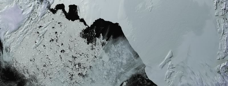
NOAA HRPT
So after some researching around I learned that it is possible to do some really cool work with the NOAA satellite data even if you don't have the
radio equipment.
For this all you need is a computer capable of some image processing and with a fair amount of space.
You will also need a program called HRPT reader http://www.satsignal.eu/software/hrpt.htm which there is a free version of.
Then if you goto the NOAA CLASS webpage http://www.class.noaa.gov you will be able to search for data sets from different satellites (but HRPT Reader can only work with the data from the
NOAA satellites)
So you can select a few sets of data from several locations all over the world (as recent as within a hour of the current time) and place them in your
'shopping cart' and order them. Ordering the data is free and they will email you with a link where you can download the data sets.
Once you download the data you can open it with HRPT Reader and process the images to your liking... Here are some cropped images from doing this:
(EDIT: it seems 110mb is having issues, changed the image locations)
Antarctica:
Vegetation Map of Northern Australia:
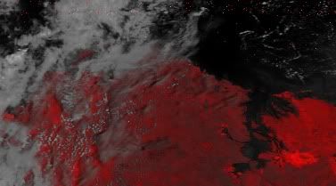
Baja Peninsula/Pacific Ocean:
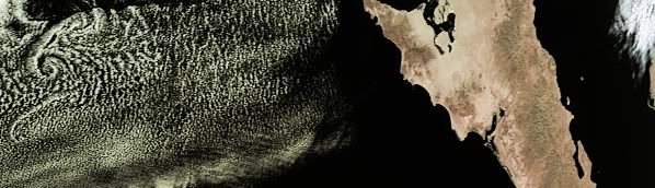
You can also get all sorts of data from the HRPT sets, such as fire data, ash maps, temperature (ocean/land/clouds), intensity maps, etc etc
Here are some links to larger more impressive images:
(EDIT: these links are valid, you just need to copy and paste them into your browser, not sure what's up with the 403 error)
Hurricane Gustav (2008):
http://scienceunderground.110mb.com/projects/5/gustav1.bmp
Gustav (2008) (large ~ 27mb):
http://scienceunderground.110mb.com/projects/5/gustav-full.b...
Western Australia (large ~ 14mb):
http://scienceunderground.110mb.com/projects/5/westernaustra...
Anyway, I find tinkering with this data to be a lot of fun and a neat way to see the weather all over the world without turning on the TV... I'll
write more about this on my web page at some point...
-ssdd
PS compare these to some of the images from OSEI : http://www.osei.noaa.gov/
[Edited on 16-1-2010 by ssdd]
[Edited on 16-1-2010 by ssdd]
[Edited on 16-1-2010 by ssdd]
All that glitters may not be gold, but at least it contains free electrons.
-- John Desmond Baernal
http://deepnorth.info/ |
|
|


